Weather monitoring system comparison: Which is right for you?

Weather monitoring system comparison: Which is right for you?

A comparison of common weather monitoring methods, pros and cons, and which technology might apply to different types of field research.

CONTRIBUTORS

As a researcher, you know the reasons for monitoring weather parameters at your research site are practically limitless. Unfortunately, the available options to make those measuremenrts are also limitless, which can be daunting when you want to know which weather station or weather monitoring system is right for your unique situation.

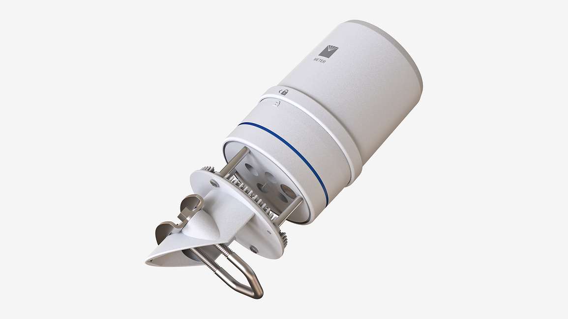
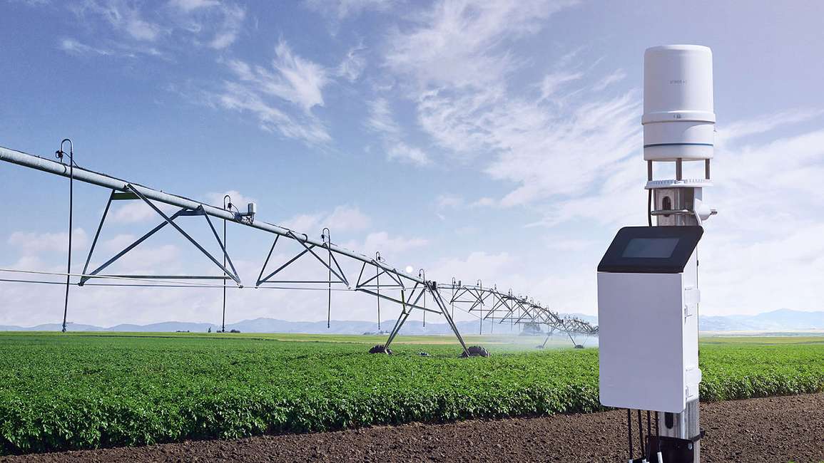
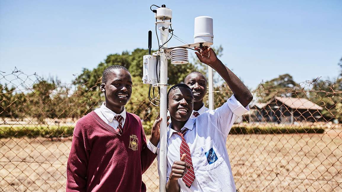
A researcher installing an ATMOS 41 all-in-one weather station in the field
Figure 1. The ATMOS 41 all-in-one weather station is one of dozens of options on the market

METER scientists have spent thousands of hours installing weather stations, and monitoring, interpreting, and publishing data from field experiments. Over time, we’ve learned a great deal about how to obtain high-quality weather data. In this article, we share that expertise with you. Watch the video or read the article below for a comparison of common weather monitoring methods, pros and cons, and which technology might apply to different types of field research. Also learn why modern weather monitoring is about more than just the weather station.

Weather monitoring systems: The performance vs. price sweet spot

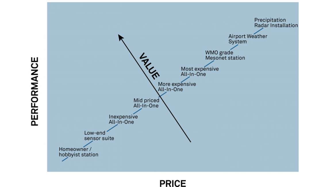
Figure 2 is a graph comparing weather station performance versus price. In an ideal world, a higher price would equal higher quality, and the price versus performance continuum would be a straight line. But choosing a weather station is not strictly about price versus performance. In Figure 2, the transverse axis is a “value” axis. If a weather station gives you a better price to performance ratio (meaning you can get exactly the right performance at a price you can afford), then that weather station will provide a higher value for your unique measurement needs.

Figure 2. Graph comparing weather station performance vs. price vs. value
Factors that affect the value of a weather monitoring system

The prices of the weather stations shown on the x axis in Figure 2 are set, so it’s only the y axis, or the performance of an instrument in your particular application that changes the value. Many different factors affect the relative performance of a weather monitoring system, such as:

  • Robustness
  • Accuracy
  • Installation and maintenance requirements Measurement suite
  • Remote data acquisition
  • Real-time data visualization
  • 4-season capabilities
  • Power requirements

Performance is defined by your unique measurement needs. For example, if you’re measuring in a remote location where you can’t access the site routinely, you’ll need extremely robust instrumentation. Robust weather monitoring equipment is also needed if people’s lives are at stake (i.e., if a sensor breaks and a flash flood isn’t detected, people’s lives could be in jeopardy). So in these situations the robustness of a weather monitoring system will drive the relative performance. Other scenarios might be as follows:

Scenario 1: You may be a climatologist monitoring air temperature to study the effects of climate change. If so, you’ll need a continuous, accurate record of air temperature for several decades. In this case, both the accuracy and the stability of a weather station or weather monitoring solution is the driving factor that affects the performance relative to your measurement needs.

Scenario 2: If you’re running a huge network of remote weather stations, and the cost of making a field trip for maintenance and installation is significant and actually dwarfs the cost of purchasing the equipment in the first place, then possibly the maintenance requirements of the instrument are what drive the performance for your application.

Scenario 3: Researchers often need specialized measurements. You may need more than the typical weather measurements such as air temperature, humidity, and rainfall to answer the research question. In this case, the type of measurement suite containing the specialized measurements you need are what drives the performance of the weather station.

Scenario 4: Some systems have three-season capabilities vs four-season capabilities. Four-season systems are heated and can function and give accurate results in high-latitude wintertime. If you’re studying wintertime precipitation you’ll need a heated rain gauge that can capture the snow precipitation. However if you’re doing an agricultural study, a four-season system won’t be important to you because plants aren’t growing.

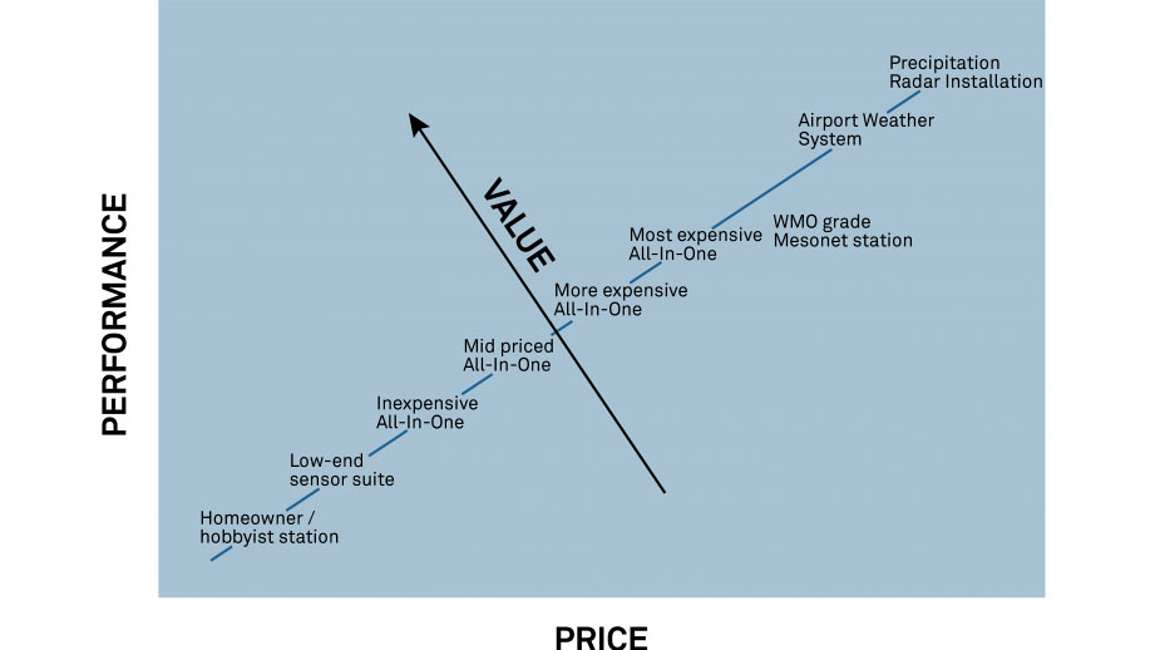
Scenario 5: Power requirements will be important if you’re monitoring at a remote location. You’ll need a battery-powered system with low power requirements, so you can reduce travel time and cost. Thus in a performance vs. value graph, any solutions that don’t meet yourweather monitoring requirements move lower on the value axis, and any that do meet your requirements move higher on the value axis. For example, if a particular WMO-grade system needs so much routine maintenance you can’t scale your network, it may move lower on the value axis, as shown in Figure 3.
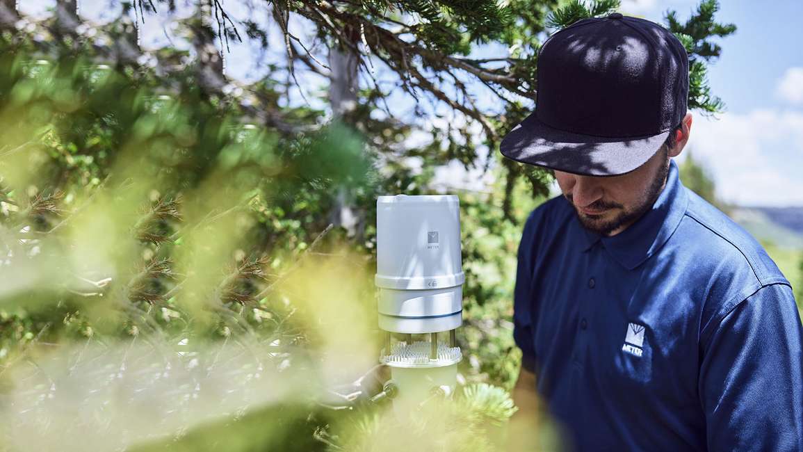
Figure 3. High maintenance system has moved lower on the value axis

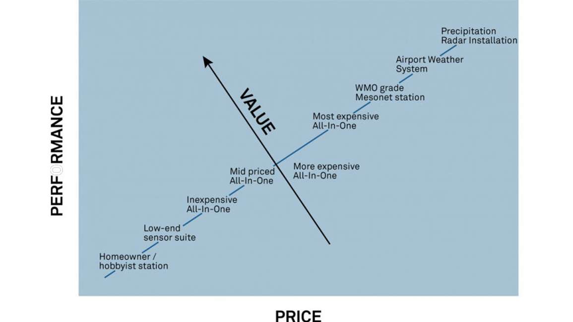
Or if you’re performing a water balance study, you’ll need a precision rain gauge. However, the more-expensive all-in-one weather station may only have a rudimentary rain gauge that measures sound generated by water droplets hitting a drum. This would drive the performance and value of this particular system down (Figure 4).

Figure 4. Non-precision rain gauge system has moved lower on the value axis

So once you determine your measurement needs and arrange the various systems on the value axis, you can see which ones are more valuable to you and where they are on the cost continuum. This enables you to make better- educated decisions about which system to use for your application.

Classes of weather stations

Below are definitions of the various types and classes of weather stations you might encounter in the marketplace.

Aviation class weather monitoring system

Aviation class weather monitoring systems are differentiated by their specialized observations.

Figure 5. Artist recreation of a typical aviation weather system

That’s why in Figure 2, if you look at the performance versus price continuum, aviation systems occupy the upper right corner where both performance and price are very high (i.e., $200,000+). They may include, for example, a visibility and present weather sensor that shows the distance that a pilot can reasonably see, a ceilometer that tells cloud height, or an instrument that indicates freezing rain or ice buildup. These specialized measurements wouldn’t be found on most weather monitoring solutions, but they do drive the performance of aviation weather systems. Aviation systems also have specialized communications with VHF transmission and redundant phone systems. And, because human health and safety depend on these systems, they are extremely robust and include four-season performance (unless they are in the tropics). In addition, the accuracy of aviation systems is very high because most of these data are piped into the climatological record.

WMO class weather monitoring system

World Meteorological Organization (WMO)-compliant weather monitoring systems are often found in national weather networks in many countries. Also some medium-scale mesonets adhere to WMO recommendations and guidelines.

Figure 6. Example of a Campbell Scientific WMO-grade weather station (Credit: www.campbellsci.asia/weather-climate)

WMO weather monitoring systems require a tower for measurements at ten meters, and other measurements are made lower down in the atmospheric profile at two or three meters. WMO-compliant systems need four-season capabilities and require high accuracy because these data also feed into our climatological record. The cost of these systems is high: approximately $20,000-$50,000, plus there are significant maintenance requirements that drive up the yearly cost of operation. This means the cost is prohibitive for dense spatial networks.

Custom weather monitoring systems

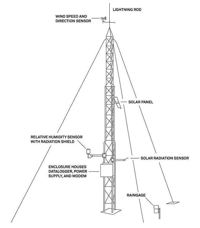
Researchers often need custom weather monitoring systems with a measurement suite tailor made for the research question they’re trying to answer. Also some weather networks use custom weather stations with a measurement suite that satisfies the needs of their stakeholders. So in addition to measuring normal weather parameters, users may add things like:

  • Infrared thermometer for measuring surface temperature NDVI
  • Redundant rain gauges
  • Net radiation for surface energy balance studies
  • A dual eddy covariance system measuring isotopic ratios
Figure 7. An NDVI/PRI sensor that might be integrated into a research weather monitoring system

There are almost an infinite number of measurements researchers can integrate into a data acquisition backbone. That’s why in the price versus performance continuum in Figure 1, these custom weather station systems are scattered along either axis. You will often see these weather monitoring systems used in non-mesonet and non-National Weather networks.

Science-grade all-in-one weather stations

In the last two decades, we have seen a proliferation of all-in-one weather stations. This means instead of piecing together weather stations with custom sensors integrated into a data acquisition backbone, many manufacturers now integrate the various weather sensors into a small-package all-in-one station.

Figure 8. ATMOS 41 all-in-one weather station

There are different types of all-in-one weather stations available, which means you have many different measurement-suite and price-point options. All-in-one weather stations cost between $1000 and $5,000, depending on the measurement suite and if it’s a three-season vs. a four-season instrument. Advantages of all-in-one weather stations are that installation and maintenance are much less complex than custom or WMO weather monitoring systems. This makes them a good option for dense weather station networks. Often you will see WMO class stations make up the backbone of a network. And then all-in-one weather stations fill the spatial gaps between those WMO class stations for a denser network with much richer information. The drawback of all-in-one weather stations is that they cannot strictly follow the WMO recommendations because they only make measurements at one height. So all-in-one weather stations have their niche just as WMO stations have theirs.

Hobbyist-grade weather monitoring system

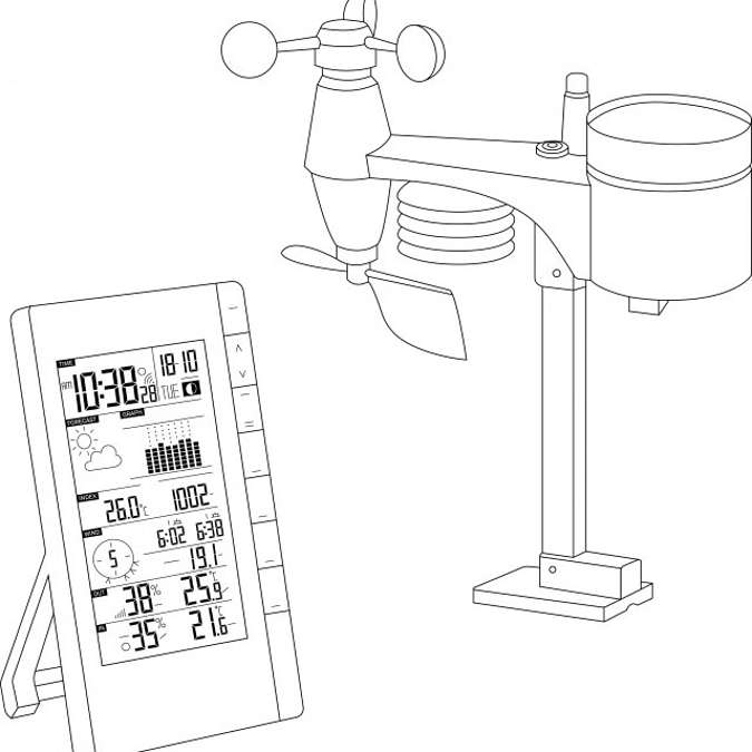
Hobbyist-grade weather stations for weather monitoring are typically built for homeowners and commercial buildings. These stations are not particularly robust and not well suited for research or long-term monitoring.

Figure 9. Example of a hobbyist-grade weather station (found on Amazon)

One advantage of these stations is that the data acquisition and communication system relays the information to a console for localized weather measurements at a house or place of business. An Amazon search will produce many of these types of weather stations in the search results.

Which weather monitoring system should you choose?

Explore the case studies below to learn how researchers and growers select the right scientific weather station for their particular application.

Case study: FAO 56 ETo for irrigated agriculture

Penman-Monteith reference evapotranspiration is a measurement commonly made in irrigated agriculture. The Penman-Monteith equation is the mechanistically based equation that quantifies the amount of evapotranspiration or water loss from either a grass surface or an alfalfa surface. For example, if you had a well-watered grass or alfalfa surface, you can plug weather variables into the equation to show how much water vapor you would lose to the atmosphere.

The measurement is generally used in high-dollar, irrigated agriculture such as vineyards and, and fruit trees, but it’s also used in center pivot applications for agriculture. Growers need to know the water balance (how much water has been lost or gained in the system) so they can replenish the net loss with irrigation water. So for this particular measurement, growers may need localized measurements at many different locations.

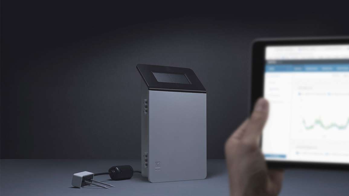
A grower typically doesn’t need a complex weather monitoring system to make this measurement. They need something easy to set up, easy to install, with low maintenance requirements, remote data access, and small battery usage. For example, the data logger in Figure 10 has just a small solar panel that will run this weather station indefinitely.

Figure 10. ATMOS 41 weather station and the ZL6 data logger have very low power requirements

The key driver of choosing a weather monitoring system for FAO 56 reference evapotranspiration is the need for both solar radiation and precipitation. Growers need to know the amount of precipitation replenishing the water in the soil, and they need a solar radiation measurement for the Penman Monteith (FAO 56) reference evapotranspiration measurements. Some all-in-one stations don’t have both precipitation and solar radiation. However, the ATMOS 41 all-in-one weather station does measure both solar radiation and precipitation. So this it’s good choice for this kind of weather monitoring in the agricultural setting.

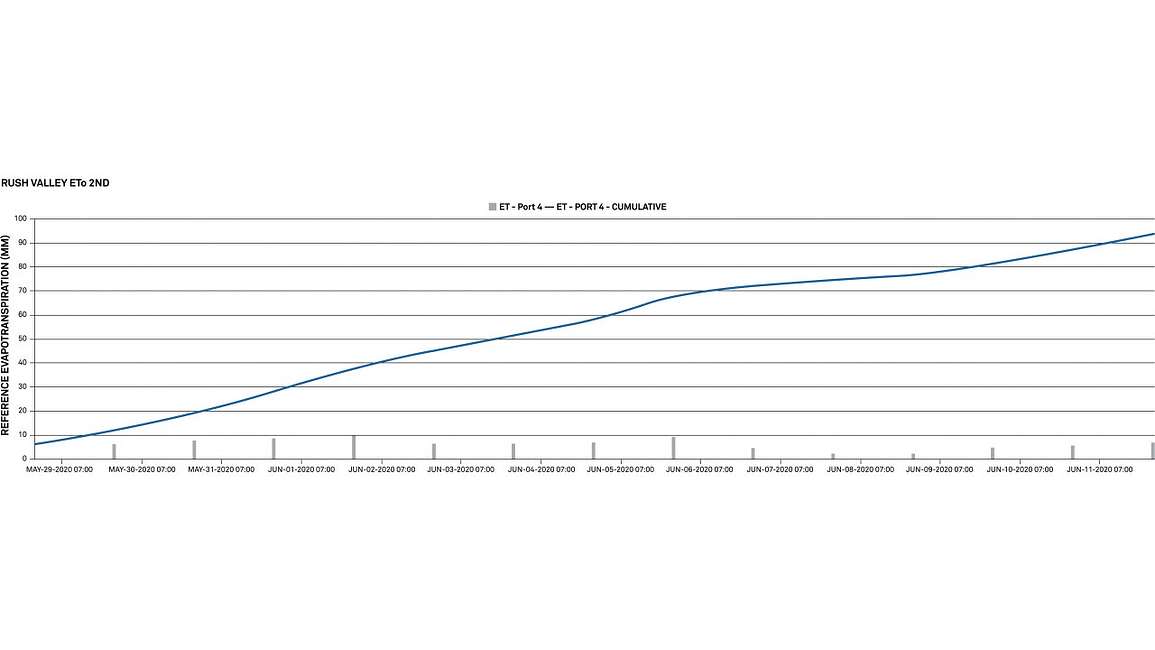
Figure 11 is a graph from the ZENTRA Cloud data management software that works with ZL6 data loggers.

Figure 11. Daily evapotranspiration data

ZENTRA Cloud automatically makes reference evapotranspiration measurements on a daily and a cumulative basis. It allows you to add the crop coefficients to convert from reference evapotranspiration into true evapotranspiration. This makes the ATMOS 41 all-in-one weather station, ZL6 data logger, and ZENTRA Cloud software a valuable turnkey system for growers.

Case study: Weather monitoring on Mt. Everest

Unlike the previous case study where ease of installation and maintenance for a few specialized measurements was important, Campbell Scientific, Inc. is involved with a project to engineer weather stations deployed on Mount Everest. One of those stations is the highest elevation weather station that is active in the world. The conditions on Mount Everest are extremely harsh, so the robustness of this station is the key factor that drives up the performance for this particular measurement need.

Figure 12. Example of CSI weather station on Mt. Everest

These Mount Everest stations are ultra robust, four-season stations because they constantly measure wintertime conditions. They include redundant specialized anemometers with coatings to shed ice and snow in case one freezes up. You can tell there’s redundancy in some of the other measurements as well. So this is not a project that was driven by price considerations. Robustness is the key driver because the cost of going up to maintain the weather monitoring system dwarfs the cost of the system by orders of magnitude.

Case study: Washington State AgWeatherNet

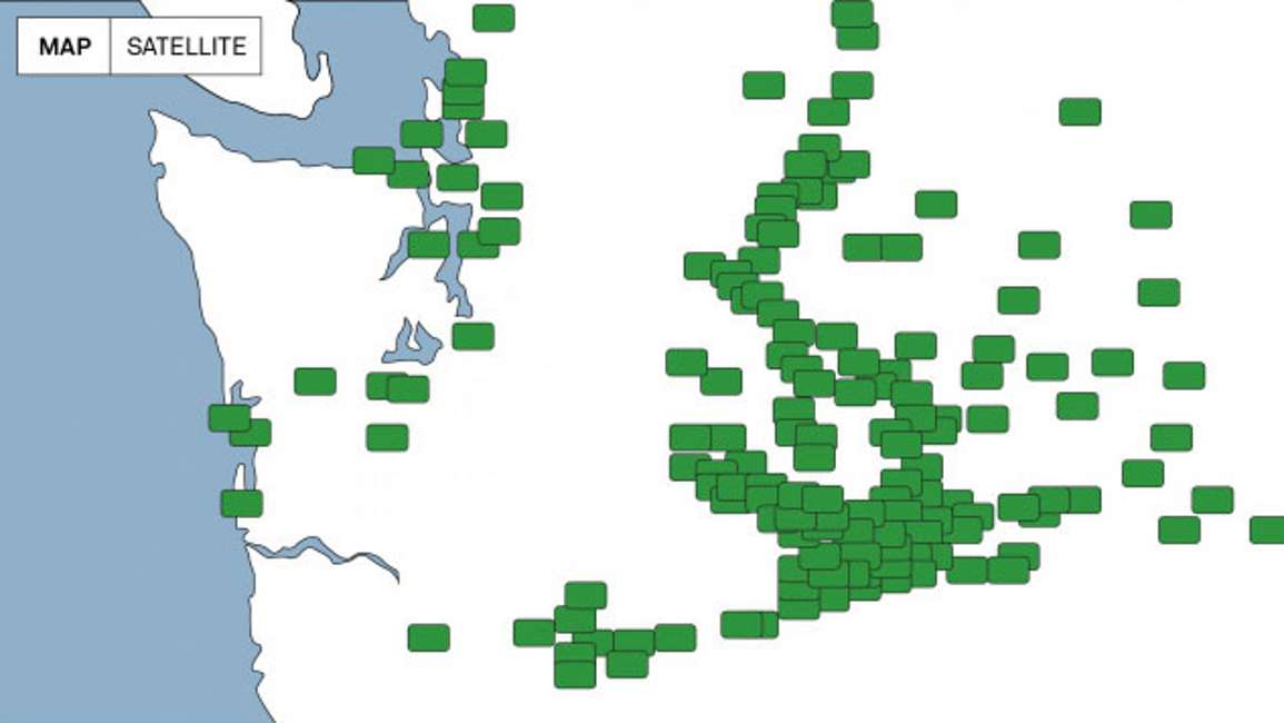
Washington State University runs the Washington State AgWeatherNet. Each green dot in Figure 13 is the location of an Ag weather Net tier-1 weather station. These stations are concentrated primarily in the agricultural regions of Washington State in apple orchards and other high-dollar crops that (along with California) feed much of the United States.

Figure 13. Locations of tier-1 AgWeatherNet stations (Original map found at: weather.wsu.edu)

AgWeatherNet tier-1 weather stations have a measurement suite tailor made for the growers in this particular region. The AgWeatherNet ingests data from these stations and outputs a number of modeled parameters like disease models, pest models, frost prediction, and frost monitoring. These models are extremely valuable for the producers in the region, who actually pay for the system.

What’s interesting about AgWeatherNet is that even though it looks like a dense spatial network, these stations are many kilometers apart. So an accurate tier-1 station sitting in a valley might measure 2 °C different than those at an orchard at the top of the hill. This means if they continuously monitor temperature and humidity in the valley and give a prediction for a fungal disease, that prediction will be different from the reality at the top of the hill.

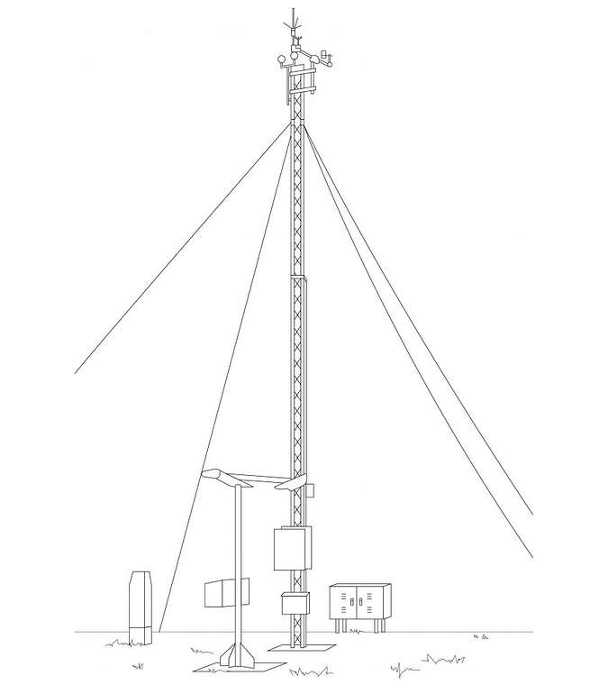
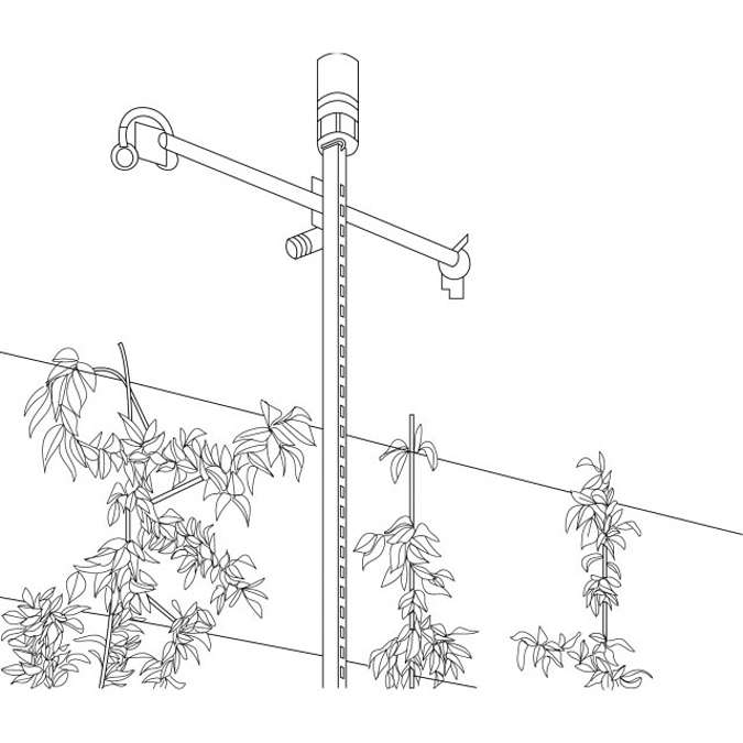
To solve this problem, the AgWeatherNet allows individual growers to purchase and install tier-2 systems (Figure 14).

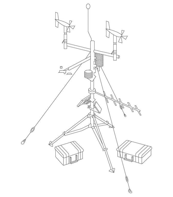
Figure 14. Simplified outline of an ATMOS 41 tier-2 weather station setup used in AgWeatherNet

Figure 14 shows an ATMOS 41 all in one weather station used in the AgWeatherNet. It doesn’t have the accuracy specs of the tier-1 stations, but the lack of accuracy at the point scale is almost inconsequential compared to the spatial difference in the weather parameters as you move away from the tier-1 sites. These tier-2 stations fill the gaps in tier-1 observations and AWN can then use artificial intelligence along with these observations to perform hyper-local predictions for the growers who put these stations in. This strategy has been successful at helping to predict mold, pest outbreaks, or frost events at a particular grower’s location. It is easy to see how each weather station type plays a key role in providing stakeholders with critical data for decision making.

Case study: Weather monitoring in Africa

It’s difficult to predict weather if you can’t even observe the weather. Outside of the country of South Africa, there are almost no weather monitoring systems on the whole continent of Sub-Saharan Africa. This has a lot of negative repercussions for weather prediction for crop insurance and for the African farmer. It’s one of the reasons it’s been difficult to get efficient farming practices adopted in Africa. To help solve this problem, METER has partnered with the Trans African Hydro Meteorological Observatory (TAHMO) to put 20,000 weather stations in Africa.

Figure 15. The ATMOS 41 all-in-one weather station was engineered specifically with the TAHMO project in mind

TAHMO had important considerations that drove the performance value of the weather stations they wanted to install. First of all, they needed a simple installation because the ground crews are not particularly skilled. They also need a low-maintenance weather station because In many regions of Africa, it is extremely difficult to make field visits because of civil unrest, political instability, and malicious activity. So routine maintenance trips to fields less than a year apart are difficult and very expensive.

The ATMOS 41 all-in-one weather station was engineered specifically with the TAHMO project in mind to be ultra-robust despite harsh weather with no moving parts that could break. TAHMO has now installed more than 500 of these weather stations in Africa and is, at this point, the largest operational weather network on the African continent. These stations have had approximately a 95% uptime while interestingly, the aviation weather systems in Sub Saharan Africa generally run at about 67% uptime.

Case study: Montana Mesonet weather monitoring systems

Typically in the U.S., the National Weather Service (a division of NOAA) puts out a network of weather monitoring systems spaced out across the country, and that data gets fed into forward-looking models that help predict the weather. Researchers are finding out that putting in a sparse network of very expensive weather monitoring systems has done really well. But the spatial gaps in those weather monitoring networks are a problem, especially for agriculture producers and ranchers. They need to know what’s happening where they are.

Figure 16. Montana Mesonet uses METER sensors paired with ZL6 data loggers and ZENTRA Cloud data management software to fill in data gaps

Mesonets present a practical solution for the need to fill in data gaps between large, complex weather monitoring systems. The Montana Mesonet currently has 57 weather stations interspersed throughout the state, and through partnerships with both the public and private sector, they’re adding more stations every year. At each location, the Montana Mesonet team installs METER all-in-one weather stations, soil moisture sensors, NDVI

sensors and data loggers that integrate with ZENTRA Cloud: an easy-to-use web software that seamlessly integrates into third-party applications through an API. Kevin Hyde, Montana State Mesonet Coordinator, says the system enables better spatial distribution and reliability. “When we were deciding on equipment we asked ourselves: What kind of technology should we use? It had to provide high data integrity. It had to be easy to deploy and maintain. And it had to be cost effective. There’s not a lot of people in that sector. METER systems are low profile, they’re affordable, and the reliability is there. I look at some other mesonets, and they cannot afford to build out further because they are relying on large, complex, expensive systems. That’s where the METER system comes into play.”

Read full Montana Mesonet case study—>

Weather station questions you should ask yourself

To sum up, your measurement needs and application define the required performance and value of a particular weather station. Important questions to ask before you buy are:

  • Does this weather monitoring system have to be ultra robust?
  • Does this system have to be hyper accurate and stable?
  • Will the station be at a field plot that my technician can visit and maintain once a week, or is this a site I’ll only be able to visit once every two years?
  • What are the particular measurements I want?
  • Does the weather station have three season vs. four season capabilities?
  • What are the power requirements? Can it run indefinitely on small batteries?

If you think through the various factors that drive the performance relative to your measurement needs, then it becomes a lot easier to decide what’s important, and you can find the best value.

Questions?

Our scientists have decades of experience helping researchers and growers measure the soil-plant-atmosphere continuum.

Weather station FAQs
Which weather station is best for greenhouse applications?

A greenhouse is an interesting environment to measure in. Some all-in-one stations are well suited for the greenhouse. The trick is to find a measurement suite that doesn’t include precipitation, so you’re not paying extra for that measurement. Part of the challenge in the greenhouse is artificial lighting. If you’re trying to measure photosynthetically active radiation then you’ll need to pay attention to your quantum sensor because most of the greenhouses are going to LED lighting which emit in discrete bands. If your quantum sensor doesn’t measure in that band, then you’re going to get the wrong answer. But there are plenty of options if you’re just looking for temperature and humidity. Even wind is important sometimes. But I would suggest one of the all-in-one weather stations for that application.

What would be the most and least frequent data logging for conventional meteorological parameters for soil plant atmosphere interaction?

This is a complex question because most of the power expense for weather monitoring systems is in broadcasting the data back to the cloud. If you need near-real-time observation, most weather stations can record every 5 to 15 minutes. But most people doing a field study in the soil-plant-atmosphere continuum collect data every 30-60 minutes. You can program your logger and some weather stations are pre programmed to give you maximum and minimum gust wind speeds so you don’t have to over sample.This will prevent you from having to do the post processing for terabytes of data.

What type of weather monitoring system would you recommend for highly granular monitoring such as hillside grapevines?

The all-in-one stations are tailor made for this application. You can find all-in- one stations in the $2,000 dollar range that will make accurate measurements. You can put several of those in the vineyard depending on topography to understand the spatial differences that are going to drive your irrigation decisions in that vineyard.

How do you test weather station sensor performance and the need for sensor recalibration?

You can buy a tier-1 sensor, like a tier-1 pyranometer weather sensor that has traceability back to Davos, and compare your solar radiation measurements against that standard. You can also buy a well-calibrated platinum resistance thermometer with an aspirated radiation shield to measure air temperature. Then you would compare your air temperature measurements against that. If you make these studies over the long term, you can quantify the drift in a particular sensor and come up with some reasonable recommendations for recalibration. At METER, we spent a lot of time doing that with our ATMOS 41 weather station. We quantify the drift we’ve observed and come up with recommendations for recalibration or refurbishment that make sense.

How can you account for dealing with maintenance costs and support from various companies producing these weather stations?

Maintenance costs can be significant. Sending people out to maintain weather stations in large networks is expensive. Most of the manufacturers of weather stations are going to give good support. So if you have a problem, you’re going to be able to find the answer. However, if you attend the American Meteorological Society meetings and look at new instrumentation, there are a number of new companies with offerings that look similar to instrumentation from reputable companies with a long track record. These new stations may not have the same performance. So you need to make sure to buy from a reputable company.

How important is metadata for the representativity of the data series and model calculations?

Knowing when your various sensors were produced and calibrated, plus understanding sensor height and location is extremely important. WMO recommendations ensure that you have the right supporting metadata, but even in research applications, metadata can make or break a study. You may have a colleague leave and all of a sudden their lab notebook has disappeared. You’ve got data coming in, but you don’t know what those data mean because you’ve lost all the supporting information. At METER we’ve spent a lot of time making metadata available all the way from the sensor through the ZL6 data logger and into ZENTRA cloud. So you have those metadata in all of your permanent records

What have you seen performance wise with the ATMOS 41 during winter, extreme winter conditions?

The ATMOS 41 all-in-one weather station is a three-season instrument, so it is not heated. In winter, the main drawback is that your funnel will fill with snow and you won’t get any precipitation measurements during the frozen part of the year. There is also the possibility that snow and ice could pack the sonic anemometer opening and attenuate wind speeds as well as the air temperature. A good wintertime precipitation measurement is a pretty intensive process. It typically takes a heated weighing gauge that you put a little oil and antifreeze on top to make sure that it doesn’t freeze and or evaporate. So it’s power intensive and pretty difficult to do right.

Does the ATMOS 41 and ZL6 conform to the ASABE Automatic Agricultural Weather Stations Guidelines?

From Table 1 of “Measurement and Reporting Practices for Automatic Agricultural Weather Stations“, the ATMOS 41 internal measurement sequence meets the sampling interval guidelines for the weather variables listed. The ZL6 data logger can be configured to report values each hour, as stated in Table 1; however, some min/max instantaneous values are not available when using the ZL6 for data acquisition and delivery. Consult the ATMOS 41 user manual for details on the output values processed in METER data loggers.

What is the footprint of the ATMOS 41?

The ATMOS 41 is a microclimate sensor, so you should position it to be representative of the climate relevant to the research questions you are asking. FAO56 gives guidelines to the positioning and field size of sensors, so if you intend to use the sensor for reference ET, follow those guidelines. The footprint of a micro-meteorological measurement depends on the height of the sensor(s), the wind speed, and the sensible heat flux and is not a simple calculation.

How frequently does the ATMOS 41 all-in-one weather station make measurements?

The ZL6 makes a measurement from each of the sensor ports in use every 60 s. However, the minimum measurement interval is five minutes for uploading data to ZENTRA Cloud. One-minute measurement interval is possible if you disable uploading data to ZENTRA Cloud, and these instructions are available upon request.

The ATMOS 41 measures the solar radiation and temperature once every 10 s and records the instantaneous values. When queried, the ATMOS 41 outputs the average of the instantaneous measurements since the last query.

The ATMOS 41 measures the wind speed and direction once every 10 s and records the instantaneous wind vector components. When queried, the ATMOS 41 outputs the average of the instantaneous measurements since the last query for wind speed and direction and the maximum instantaneous wind speed value for wind gust.

If using a non-METER logger, then the ATMOS 41 can be scanned every three seconds, but it is not necessary to oversample the ATMOS 41 and compute averages, accumulations, and maximums in external data systems because the ATMOS 41 has an internal measurement sequence [see the integrator guide for more information]. Less frequent sampling has the additional benefit of decreasing data acquisition systems and ATMOS 41 power consumption.

Does the ATMOS 41 need to be powered continuously?

Yes. There isn’t a way to get meaningful data from the ATMOS 41 without powering it continuously and letting its internal measurement sequence operate. The ATMOS 41 could be powered up at a set interval, allowed to take the first set of measurements, and then those could be output. But this scheme would miss nearly all precipitation, nearly all lightning, and would grab a single, instantaneous value of wind speed and direction, which is almost meaningless considering the inherent variability in wind. One thing to note is that the ATMOS 41 has been designed specifically to use as little power as possible in normal continuous-power mode. The average current consumption is on the order of 200 micro-amps. Even if the non-METER data acquisition device runs on just a few AA cells, it should be able to sustain this power draw for a very long time.

How does the ATMOS 41 anemometer compare to other sonic anemometers?

See ATMOS 41 comparison testing and sensor-to-sensor variability data here.

What is the practical lower limit of the wind speed measurement for the ATMOS 41?

The practical lower limit for wind speed is about 0.03 m/s for our sonic anemometer. This is much better than cup anemometers, for example, which struggle making measurements below 0.5 m/s at the minimum because of difficulty starting and stopping. Sonic anemometers can read five times lower than that, yet they don’t necessarily read absolute zero.

How does the ATMOS 41 record an accurate air temperature without a radiation shield?

The ATMOS 41 collects all of the information necessary to correct for absorbed radiation in a biophysical model. Because the ATMOS 41 also measures wind speed and solar radiation, it is possible to use a simple energy balance calculation to correct the Tair measurement. After correction, error decreases to < 0.5 °C and yields better accuracy than commonly used passive ventilation radiation shields.

The equation and experimental results are available in our application note and in the video below.

What are installation best practices for weather stations?

1. Location: Make sure the location you choose for any weather monitoring system will give you answers to the questions that you want answered. If you’re looking for general weather monitoring, make sure the location is far (at least 3X height of tallest obstruction) from any obstructions to wind. Make sure the vegetation is representative, and make sure the topographical location is representative. Rooftops are pretty bad generally, as are deep valleys or hilltops. If you’re looking for reference ET, you’ll want to deploy in the field with at least a few meters of crop on all sides of the installation. Also make sure that nothing is going to shade the solar radiation sensor.

2. Height: A lot of groups mount the ATMOS 41 at 2 m height, because this is the norm for reference evapotranspiration. Others go higher for meteorological observations. Some even deploy in the canopy for specialized research questions. You can deploy easily at whatever height you want as long as you have the right mounting apparatus.

3. Mounting apparatus: The ATMOS 41 is designed to mount on a vertical rod (see the user manual and quick start guide for exact dimensions). It is often deployed on a vertical pole anchored by either guy wires or by a good-quality tripod. Some even mount on T-posts, preferably with some guy wires to add stability.

4. Level: This is important for the ATMOS 41. You need to have it level to within 2 degrees in both the X and Y. There’s a bubble level underneath the rain funnel that you can see from below and use to get level. The ATMOS 41 also outputs x and y level as standard outputs, so you can make sure you’re within 2 degrees of zero. You’ll need to use the guy wires to pull the mounting apparatus level or add some shims to achieve proper level.

5. Check the data flow before you leave the field: Take a laptop (or handheld device if you’re using the ZL6 data logger) and the right software to make sure all the connections are good and that your data acquisition system is recording and/or transmitting data properly. A good best practice is to set it all up in the lab or office first, troubleshoot any issues, and then go to the field.

6. Always take a complete toolset: You never really know what you’re going to need when troubleshooting unique situations.

7. Tidy up the wires: The single biggest failure mode for environmental sensors in a weather monitoring system is the wiring. Zip tying extra wire to the mounting mast can keep it from getting snagged by animals or whipped around in windstorms and unplugged from the data logger. Protecting the wiring in a cage or other container is great if you have the ability to do so. Any of these things make the installation look more professional, which is an added bonus.

8. For more info: Watch the webinar below—7 Weather Station Installation Mistakes to Avoid

Learn more

Our scientists have decades of experience helping researchers and growers measure the soil-plant-atmosphere continuum.

Measurement insights

Scientific weather station performance data and weather sensor comparisons

We performed comparison testing for ATMOS 41 vs. high-quality, research-grade non-METER sensors and conducted time-series testing for sensor-to-sensor variability. Here are the results.

READ MEASUREMENT INSIGHT

Weather monitoring system comparison: Which is right for you?

A comparison of common weather monitoring methods, pros and cons, and which technology might apply to different types of field research.

READ MEASUREMENT INSIGHT

Lab vs. field instruments—Why you should use both

Lab and field instruments used together can provide researchers a symphony of information and can be used as powerful tools in understanding data and predicting a soil’s behavior over time.

READ MEASUREMENT INSIGHT

Case studies, webinars, and articles you’ll love

Receive the latest content on a regular basis.

icon-angle icon-bars icon-times